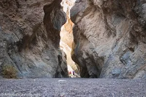
Grotto Canyon – Death Valley National Park
Explore a desert canyon with multiple dryfalls that must be scrambled to end in a rock grotto below a 40ft. dryfall. A rope may be helpful for scrambling the dryfalls, but it is not required if you’re good at bouldering. Directions for possible bypasses are included.
| Total Distance: 1.2-2.8 miles out & back | Elevation Gain: 797ft. (778ft. to 1,575ft.) |
| Difficulty: Moderately Strenuous | 0-5 Mile Difficulty: Strenuous |
| View Rating: 3.0 out of 5.0 stars | Author’s Rating: 4.0 out of 5.0 stars |
| Visitor Rating: (Click to rate) [Total: 0 Average: 0] | Visitor Difficulty Rating: (Click to rate) [Total: 0 Average: 0] |
| Pets: No | Horses: No. You’d never get a horse up this trail. |
| Best Seasons: November-April | Special Permits: None |
| Water Availability: None | Overnight Options: None |
| Trailhead Amenities: None | Crowd Factor: Moderate |
| Trailhead Access: 1.4 to 2WD Trailhead; 2.0 beyond | |
| Uses: | Trail Surface: |
| Features: | Hazards: |
Mile-by-Mile: Grotto Canyon
-0.9 2WD, Low Clearance Trailhead (442ft.). If you have a 2WD vehicle, park here above where the road descends sharply into the wash. Take to your boots to drop into the wash and turn left to hike up the road as it winds up the canyon, with the canyon walls slowly closing in around the road. Be wary of jeeps and 4×4 vehicles potentially coming up or down the road. Note: As of fall 2023, the 2WD Trailhead is the only trailhead, as the road up the canyon, itself, has been washed out. Please respect any closures that may be in effect. (36.591435°, -117.110564°)
0.0 Grotto Canyon Trailhead (778ft.). Continue up the wash. It’s hard to get lost since the wash goes pretty much in one direction without sidecanyons. (36.582174°, -117.103872°)
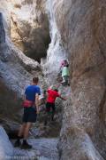
0.2 First Dryfall (865ft.). This 20ft. dryfall is the most difficult dryfall in lower Grotto Canyon – coming down is more difficult than going up due to the height, angle, and smoothness of the rock. You may need to use a rope to assist in getting up or down the dryfall. Once above the obstacle, continue a short distance upcanyon. (36.579844°, -117.103015°)
Look below for the directions to potentially bypass the first and second dryfall as well as the choke stone.
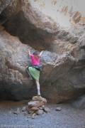
0.25 Second Dryfall (883ft.). The 8ft. dryfall is more difficult for shorter people, but it can prove a challenge for anyone. Helpful previous hikers have constructed a pile of rocks that makes climbing up onto the ledge much easier. Directly above the second dryfall, a chokestone blocks forward progress. Stay right to wiggle your way up into the next, much wider, section of canyon. (36.5798000°, -117.1029333°)
Bypass for the first dryfall, second dryfall, and choke stone: About 0.1 miles below the first dryfall (approx. 36.581205, -117.103430), head up the east (left coming upcanyon) side of the canyon following a cairned path. The route should take you up to the ridgeline with excellent views down toward Stovepipe Wells. It then works its way down via a wash to Grotto Canyon above the choke stone (approx. 36.579690°, -117.102548°).
0.5 Third Dryfall (1,039ft.). At about only 10ft. tall, the narrow dryfall seems easy, but it poses a significant challenge unless you’re used to chimneying up narrow spaces and are wearing grippy shoes (most hiking boots should be fine) – the rock is smooth and slick in this section. (36.576664°, -117.101945°)
See below for the bypass instructions around the third dryfall and the second choke stone.
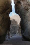
0.55 Second Choke Stone (1,056ft.). A six-foot ledge beside a large chokestone is the last major obstacle in this part of the canyon. After scrambling up it, the canyon widens for a moment before entering an even narrower channel between towering canyon walls. (36.576630°, -117.101771°)
Third Dryfall and Second Choke Stone bypass: Walk back downcanyon to where the narrows more or less end, approx. 36.576697°, -117.102271°. Head up the north/east side of the canyon (left if you’re coming upcanyon) to scramble above the canyon rim and then drop back into Grotto Canyon in the wide section, approx. 36.576548°, -117.101566°.
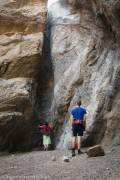
0.6 Grotto (1,148ft.). A 40ft. dryfall blocks upward travel. Enjoy the peaceful canyon below the pouroff with towering walls on all sides before traveling back downcanyon to your vehicle or proceeding to Upper Grotto Canyon. Many people turn around here due to the sketchy nature of the bypass trail. If you wish to continue into the upper canyon, retrace your steps about 0.1 miles to a short distance beyond where the canyon widens. (36.575961°, -117.100693°)
0.7 Social Trail to Upper Grotto Canyon (1,065ft.). Near a turn in the canyon, an eroding social trail strikes up the north (right when coming downcanyon) side of the canyon. Scramble (class 3) up this sketchy often slippery trail, then take the firmer trail along the edge of the canyon rim and around rocks to the canyon above the Grotto. Be careful, as the trail is very narrow at times with some uncomfortable exposure. The trail should drop you down just above the top of the 40ft. dryfall. (36.576134°, -117.101437°)
0.75 Top of Dryfall above the Grotto (1,179ft.). Turn left to continue up the canyon. It twists and turns among narrow walls, with occasional easily navigated dryfalls. When in doubt, most of the dryfalls can be scrambled on their right side. (36.575921°, -117.100612°)
1.1 Third Choke Stone (1,376ft.). This is the end of Grotto Canyon for most hikers who come up this far. If you’re good at scrambling, you can ascend to the right (west) side of the 15ft. chokestone, or you may be able to find an overland route. If you make it up, continue right at the canyon fork to walk up the main wash. More small dryfalls are fun diversions from the canyon hike. (36.572045°, -117.101586°)
1.4 Dryfalls (1,575ft.). There may be ways to scramble around the dryfalls or to backtrack and take an overland trail up and around the obstacles. However, the canyon has many obstacles above this, so explore to your heart’s content. Another option is to backtrack to the sidecanyon on the east (right when coming downcanyon) side of the main wash. You may be able to explore for a distance before obstacles block progress. (36.569108°, -117.103494°)
History & More
Grotto Canyon requires significant scrambling. Most hikers give up at the first dryfall, and with good reason. You’ll want to enjoy scrambling and exploring to complete the rest of the route.
A length of rope (30ft.) can be helpful on some of the dryfalls. I didn’t use it at all except on the first dryfall – it was just a little too slick for me. It also allowed us to haul up and let down our packs instead of being strapped into them while scrambling.
I went into the Upper Canyon, but I didn’t quite make it to the first significant dryfall above the Grotto. Hopefully I will go farther someday!
The bypasses are not part of the regular trail and may contain Class 3+ scrambling, loose slopes, other hazards, or disappear at critical moments. Use at your own risk.
Download Trail Map
Coming soon!
Driving Directions
The 2WD Trailhead is at the end of a 0.2 mile gravel access road. The access road is along CA-190 2.2 miles east of Stovepipe Wells and 22 miles northwest of Furnace Creek.
Remember, it may be easier to climb up dryfalls than down them (or vice versa). Be sure you can climb in the other direction before climbing up or down a dryfall.
Leave No Trace Principles are enforced
Drones and model aircrafts are prohibited
Camping is permitted only in designated sites or in areas open to dispersed backcountry camping
All park rules and regulations
12 Month Pass: $55/Death Valley Annual Pass (valid at Death Valley National Park). $80/America the Beautiful Annual Pass (valid at all national park and federal fee areas). $20/Annual Senior Pass (62 years or older US citizens; valid at all national park and federal fee areas). Free/4th Grade Pass (Valid Sept. 1-August 31 of the child’s 4th Grade school year). Free/Military Pass (valid for all active military personel and their dependents with a CAC Card or DD Form 1173).
Lifetime Pass: $80/Lifetime Senior Pass (62 years or older US citizens; valid at all national park and federal fee areas). Free/Access Pass (available to all US citizens with perminent disabilities). Free/Access for Veterans and Gold Star Families Pass (valid for all military and veterans with a CAC card, Veteran HJealth Identification Card, Veteran ID Card, or veteran’s designation on state-issued drivers license or identification card.)


