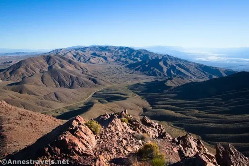
Daylight Peak – Death Valley National Park
Climb an unofficially named peak to the west of Daylight Pass to spectacular views.
| Total Distance: 2.0 miles out & back | Elevation Gain: 1,261ft. (4,321ft. to 5,516ft.) |
| Difficulty: Moderate | 0-5 Mile Difficulty: Strenuous |
| View Rating: 4.0 out of 5.0 stars | Author’s Rating: 3.0 out of 5.0 stars |
| Visitor Rating: (Click to rate) [Total: 0 Average: 0] | Visitor Difficulty Rating: (Click to rate) [Total: 0 Average: 0] |
| Pets: No | Horses: Yes |
| Best Seasons: November-April | Special Permits: None |
| Water Availability: No potable water | Overnight Options: None |
| Trailhead Amenities: None | Crowd Factor: Solitude |
| Trailhead Access: 0.6 | |
| Uses: | Trail Surface: |
| Features: | Hazards: |
Mile-by-Mile: Daylight Peak
0.0 Parking area in Daylight Pass along the Daylight Pass Road (4,321ft.). Beginning by the sign with the elevation of Daylight Pass, head due west to find the old road to the spring. (36.788731°, -116.931967°)
300ft. Old Water Spigot (4,350ft.). Continue west to find the road. (36.788646°, -116.932861°)
0.1 Wire across road (4,375ft.). This is the remains of an old gate that kept vehicles away from the spring. Follow the old road westward. Pass a spring area about mile 0.25. (36.788670°, -116.933457°)
0.3 More or less end of the road (4,462ft.). The road ends here, and the brush around the spring is nearby. Turn left (south) and head south and west for a drainage that works its way up the peak to the west. (Note: I tried to go up the eastern arm of the mountain; while it starts out gentler, it fairly quickly becomes very steep talus slopes that is no easier than the “drainage route.”) (36.789130°, -116.936702°)
0.4 Drainage (4,529ft.). Turn right (west) and follow the drainage more or less toward the peak. About halfway up, leave the main drainage to head north up the scree. You’re trying to crest the ridgeline just left (west) of the red cliff formations on the east arm but to the right of Daylight Peak (which is extremely steep at the top), but chances are that you’ll need to head up toward the red cliffs and then make your way left a little to their end. The tread of the drainage and the slope is extremely steep scree; use care to both leave no trace and still keep your footing. (36.787629°, -116.937707°)
0.9 Ridgeline (5,361ft.). Turn left (south/west) to walk along the ridgeline to the peak. This is an easy trek compared to the scree slope you just ascended. A brief scramble up the rocks will bring you to the pile of rocks marking the summit. (36.7880450°, -116.9441710°)
1.0 Daylight Peak (5,516ft.). Enjoy spectacular views over Death Valley and the surrounding mountains. The ridgeline continues down to a peak known as “5510T” on topo maps – you’re welcome to hike down to this point, though the peak with the summit register has the better of the two views. (36.7871190°, -116.9456090°)
History & More
The peaks on this side of Daylight Pass are in the Grapevine Mountains. Across the road to the south is the Funeral Mountains.
Early explorers of Death Valley found wild grapevines growing in the mountains and gave the range its name.
The tallest peak in the Grapevine Mountains is (not surprisingly) Grapevine Peak, reaching heights of 8,738ft.
The route up Daylight Peak is steep and unstable. You should be very familiar with hiking off-trail in challenging terrain before attempting this one.
On my initial ascent of the peak, I attempted an easier-looking route up the east arm, then along the base of the red cliffs. Overall, this was not an easier ascent, which is why I recommend the route above (my route down).
Download Trail Map
Coming soon!
Driving Directions
Take the Daylight Pass Road (signed for Beatty) from Scotty’s Castle Road. At 6.7 miles, bear left to stay on the Daylight Pass Road. Keep climbing up to Daylight Pass, 6.2 miles later. The pass is also 13.1 miles southwest of Beatty, Nevada.
Leave No Trace Principles are enforced
Drones and model aircrafts are prohibited
Camping is permitted only in designated sites or in areas open to dispersed backcountry camping
Click here for all park rules and regulations
12 Month Pass: $55/Death Valley Annual Pass (valid at Death Valley National Park). $80/America the Beautiful Annual Pass (valid at all national park and federal fee areas). $20/Annual Senior Pass (62 years or older US citizens; valid at all national park and federal fee areas). Free/4th Grade Pass (Valid Sept. 1-August 31 of the child’s 4th Grade school year). Free/Military Pass (valid for all active military personel and their dependents with a CAC Card or DD Form 1173).
Lifetime Pass: $80/Lifetime Senior Pass (62 years or older US citizens; valid at all national park and federal fee areas). Free/Access Pass (available to all US citizens with perminent disabilities). Free/Access for Veterans and Gold Star Families Pass (valid for all military and veterans with a CAC card, Veteran HJealth Identification Card, Veteran ID Card, or veteran’s designation on state-issued drivers license or identification card.)


