Hungry Bill’s Ranch to Panamint City – Death Valley National Park


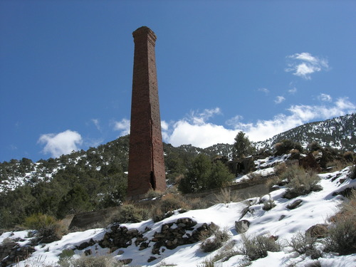
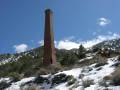
Photo credit Joe Decruyenaere, CC BY-SA 2.0. View at https://flic.kr/p/9u29MB
Hike up an old route to an 8,000ft. pass and then down to a historic ghost town. Note that the route is not maintained and may be difficult to travel or be invisible.
| Total Distance: 13.2 miles out & back | Elevation Gain: 6,596ft. (3,837ft. to 8,076ft.) |
| Difficulty: Very Extremely Strenuous | 10+ Mile Difficulty: Very Extremely Strenuous |
| View Rating: 5.0 out of 5.0 stars | Author’s Rating: 3.0 out of 5.0 stars |
| Visitor Rating: (Click to rate) [Total: 0 Average: 0] | Visitor Difficulty Rating: (Click to rate) [Total: 0 Average: 0] |
| Pets: No | Horses: No |
| Best Seasons: March-June, September-November | Special Permits: None |
| Water Availability: No potable water | Overnight Options: Dispersed camping permitted at least 100 feet from any water source |
| Trailhead Amenities: None | Crowd Factor: Solitude |
| Trailhead Access: 2.3 | |
| Uses: | Trail Surface: |
| Features: | Hazards: |
Mile-by-Mile: Hungry Bill’s Ranch to Panamint City
0.0 Cottonwood Trees near the end of the Johnson Canyon Road (3,837ft.). Park in the turn around area and then follow the remains of the road up along the runoff from Wilson Spring up to the end of the old road, then hike up the trail/route to Hungry Bill’s Ranch. (36.088866°, -117.006300°)
1.75 Hungry Bill’s Ranch (4,737ft.). From here, you want to continue upcanyon. As the ranch sprawls, there may be social trails to follow for a while, especially until you can drop into the canyon above most of the greenery created by the springs. This guide turns slightly left to walk along the south side of a rambling stone wall and then picks up a social trail to continue upcanyon on the south side of the canyon before crossing to the north side of the canyon and finally dropping into the wash above the greenery about mile 2.2. A quarter mile later (36.098077, -117.038432), be sure to take the left (southerly) fork to continue upcanyon. Note that because of the tangled mess of foliage in the upper canyon, this entire route is very difficult. (36.092049°, -117.029525°)
2.8 Greenery from a spring (5,441ft.). The spring extends up the canyon to the right; you want to take the left fork to ascend up toward Panamint Pass. (36.100064°, -117.042495°)
3.7 Wash split (6,201ft.). There have been several wash splits before this, but this one has the washes spreading out on either side of a red hill. Take the left (southerly) wash to ascend toward Panamint Pass. The pass, itself, is out of sight at the moment, but it’s to the right of Sentinel Peak, which is visible to the southwest. The route is rugged and becomes steeper as you get closer to the pass. (36.101670°, -117.055450°)
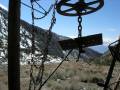
4.7 Panamint Pass (8,076ft.). Snow may cling here into the spring months due to the elevation. Continue across the pass and down into Frenchmans Canyon. If in doubt of where to go, simply continue downcanyon. You may see evidence of mines along the way – the area was heavily prospected in the boom days of Panamint City. (36.107109°, -117.070165°)
6.3 Surprise Canyon (6,483ft.). Thompson Camp is just upstream (right) from here, but this guide turns left down the wash toward Panamint City (if you want easier walking, cross the wash and scramble up to the old road). (36.119868°, -117.089721°)
6.6 Upper extremities of Panamint City (6,292ft.). The ghost town sprawls, so there is plenty of exploring that can be done. Remember that the buildings are private property, so explore with respect. Be careful to take the correct branches of the wash on the way back up Frenchmans Canyon on your way back to Johnson Canyon (probably the most confusing is at 36.118776°, -117.085108°; take the right (southerly) fork). (36.117792°, -117.095193°)
History & More
At one time, the road up Johnson Canyon ascended all of the way to Panamint Pass and then down Surprise Canyon to emerge not far from the ghost town of Ballarat. In 2001, Death Valley National Park and nearby local agencies closed the road beyond Wilson Spring. That said, there is little to no evidence of vehicle usage in the upper canyon.
The peak to the left of Panamint Pass is called Sentinel Peak. It’s visible from much of the route.
Don’t underestimate the difficulty of this hike. Besides being over 13 miles RT, the elevation gain is killer. And if all that wasn’t enough, the upper part of the canyon is choked with brush, which is miserable to try and push through. Give yourself extra time and energy for this hike!
William Johnson established a ranch in the canyon that bears his name in the 1870s. By building irrigation channels and terraces, he was able to successfully raise squash, melons, corn, beans, and even fruit and nut orchards. It wasn’t just a homestead – William carried his produce five miles over the Panamint Mountains to the swelling mining town of Panamint City. As the town began to dwindle, William abandoned the ranch. However, the route that he used is the basis for this trail.
Johnson Canyon was also rich in mineral resources. Both gold and silver were extracted by prospectors and natives (each with their own claims). It’s said that some miners tried to jump a claim owned by several Shoshone men. The men went to a nearby city, rounded up some (possibly drunken) miners, and ran the jumpers off of their land.
Panamint City was established in 1872 in the wake of a silver and copper boom. Within two years, the city had 2,000 residents. In 1876, a flash flood washed away most of the town; however, a post office existed from 1882-83 and 1887-95.
A few people continued to live in Panamint City until 1983, when another flash flood tore out the road to the town, making living there an unappealing option. Private property still exists, however, and the owners are still allowed to drive up to their property, even after the Bureau of Land Management permanently closed what was left of the road in 2001.
Much of Surprise Canyon is part of Death Valley National Park; however, the road and buildings are still private property.
Before the initial silver strike in Surprise Canyon, several men had claims in the canyon. They were followed home one day by six stagecoach robbers and forced into a partnership. Eventually, two Nevada senators backed the development of the mines in the area.
Panamint City had a reputation for being lawless and ruthless. Wells Fargo refused to build an office there for fear that any money or packages would be stolen before they could be delivered.
With no way to safely transport their rich finds and with lawlessness running high, the Nevada senators finally cast their silver bullion into 450lb. cannonballs. These were hauled to Los Angeles in a wagon that didn’t carry even one guard for protection.
Download Route Map
Driving Directions
End of the Johnson Canyon Road, 9.8 miles from the West Side Road.
It is extremely dangerous to enter a mine due to unstable shafts, gasses, and more. Do not enter mines, even if they are apparently open!
Walking on, climbing, entering, ascending, descending, or traversing any mine, structure, feature, or ruin is prohibited.
Toxic chemicals or ore may be present around mine sites. Enter at your own risk.
Possessing, destroying, injuring, defacing, removing, digging, or disturbing any mine, structure, feature, or ruin is also prohibited.
Always be wary of flash floods in a canyon.
Camping in a canyon is discouraged due to the danger of flash floods.
Remember, it may be easier to climb up dryfalls than down them (or vice versa). Be sure you can climb in the other direction before climbing up or down a dryfall.
Camping is not allowed within one mile of a paved road, developed area, or dirt road that is closed to camping.
Camping is not permitted within 100 feet of a flowing stream, spring, or other natural body of open water.
No camping is permitted on the floor of Death Valley, within one mile of Darwin Falls and Greenwater Canyon, on the active/shifting sand dunes, and certain other canyons and backcountry areas.
Camping is also prohibited within one mile of the Ubehebe Lead Mine, Leadfield Mines, Keane Wonder Mill, and Skidoo Mill.
Camping is limited to 30 days per calendar year within the park.
Fires are permitted in NPS-provided fire grates or grills ONLY.
Leave No Trace Principles are enforced
Drones and model aircrafts are prohibited
Camping is permitted only in designated sites or in areas open to dispersed backcountry camping
All park rules and regulations
12 Month Pass: $55/Death Valley Annual Pass (valid at Death Valley National Park). $80/America the Beautiful Annual Pass (valid at all national park and federal fee areas). $20/Annual Senior Pass (62 years or older US citizens; valid at all national park and federal fee areas). Free/4th Grade Pass (Valid Sept. 1-August 31 of the child’s 4th Grade school year). Free/Military Pass (valid for all active military personel and their dependents with a CAC Card or DD Form 1173).
Lifetime Pass: $80/Lifetime Senior Pass (62 years or older US citizens; valid at all national park and federal fee areas). Free/Access Pass (available to all US citizens with perminent disabilities). Free/Access for Veterans and Gold Star Families Pass (valid for all military and veterans with a CAC card, Veteran HJealth Identification Card, Veteran ID Card, or veteran’s designation on state-issued drivers license or identification card.)