Hungry Bill’s Ranch & Upper Johnson Canyon – Death Valley National Park


Photo credit The Greater Southwestern Exploration Company, CC BY 2.0. View at https://flic.kr/p/aH5dY2
Follow a stream in the desert up to the ruins of an old ranch with rich history and fruit trees.
| Total Distance: 3.5 miles out & back | Elevation Gain: 1,468ft. (3,837ft. to 4,738ft.) |
| Difficulty: Strenuous | 0-5 Mile Difficulty: Very Strenuous |
| View Rating: 3.0 out of 5.0 stars | Author’s Rating: 3.0 out of 5.0 stars |
| Visitor Rating: (Click to rate) [Total: 0 Average: 0] | Visitor Difficulty Rating: (Click to rate) [Total: 0 Average: 0] |
| Pets: No | Horses: No |
| Best Seasons: October-May | Special Permits: None |
| Water Availability: No potable water | Overnight Options: Dispersed camping permitted at least 100 feet from any water source |
| Trailhead Amenities: None | Crowd Factor: Solitude to Moderate |
| Trailhead Access: 2.3 | |
| Uses: | Trail Surface: |
| Features: | Hazards: |
Mile-by-Mile: Hungry Bill’s Ranch & Upper Johnson Canyon
0.0 Cottonwood Trees near the end of the Johnson Canyon Road (3,837ft.). Park in the turn around area and then follow the remains of the road up along the runoff from Wilson Spring. Turn left (south) to continue up the old road through the foliage that springs up from the water provided year-round from the spring. After 500ft., a wide area on the left may lead to something interesting – or not. Continue up the old road. (36.088866°, -117.006300°)
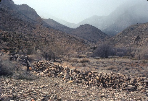
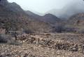
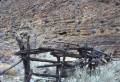
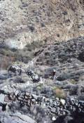
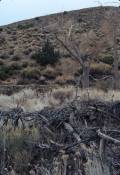
0.15 End of old road (3,907ft.). The route after this is most definitely a trail. As you hike, keep your eyes open for three arrestees (they look like stone fire pits) – the first is after 0.1 miles on your left, and is the best preserved, while the others are further upcanyon (approximately 0.4 and 0.9 miles beyond the first one), though these are in worse shape and are more difficult to spot. Continuing upcanyon, the trail follows the creek between small waterfalls and pools – use the trail on the left (south) side of the canyon to avoid the worst of the foliage and wet areas on the canyon floor. Multiple social trails crisscross (and dead end in) the area, but the main path is often (but not always!) on the south side of the canyon and sometimes along the canyon rim. Along the way, you’ll likely find man-made stone walls and stabilization from one or more of the multiple cultures and generations who lived and worked in this canyon. About mile 1.2, cross the creek twice near an unnamed spring and then come to the first clearing of Hungry Bill’s Ranch. Johnson’s Ranch is further upcanyon, near the remains of cleared fields and many more stone walls. (Actually, we’re not completely sure on who owned what, but it’s a good guess). (36.090298°, -117.007157°)
1.75 Hungry Bill’s Ranch (4,737ft.). There is much to explore in the area – fields, stone walls, orchards, terraces, irrigation channels, and much more. (36.092049°, -117.029525°)
History & More
Note that while the route to Hungry Bill’s Ranch is an official trail, it’s not really maintained. This means that there are multiple social trails that can be confusing along the way. Be ready to find your own way – though since you’re just heading upcanyon, it’s hard to get really lost. Also, be ready for steep slopes, some nice dropoffs, and brushy sections (slacks and long sleeves are recommended).
Be careful around the stone structures – rattlesnakes often like to hide among the rocks.
Arrestees look like circular stone fire pits. In reality, they were used like simple mills to turn gold or other ore into smaller chunks to extract metals from the rock before sending the ore to civilization for more careful processing.
No one knows who, exactly, built the stone walls on the trail to Hungry Bill’s Ranch. While they’re a work of art and ingenuity, it’s up to you to dream about who needed them and why.
Johnson Canyon was the site of a Shoshone village. The locals still used the spring in the early days of settlement and prospecting in Death Valley.
William Johnson established a ranch in the canyon that bears his name in the 1870s. By building irrigation channels and terraces, he was able to successfully raise squash, melons, corn, beans, and even fruit and nut orchards. It wasn’t just a homestead – William carried his produce five miles over the Panamint Mountains to the swelling mining town of Panamint City. As the town began to dwindle, William abandoned the ranch.
History melded when, in 1907, a Shoshone man by the name of Hungry Bill and his family moved into the canyon and was approved for a homestead on the land. The family planted more trees and gardens and lived on the site of their ancestral village until Hungry Bill’s death c.1919.
There was some discussion after the filing of the homestead whether or not an American Indian man could, indeed, file a claim. The state of California upheld his rights to the land.
Hungry Bill was famous for his ravenous appetite. We don’t know if any of his family inherited that trait, but it’s possible that hunger drove the family to build ever-increasing numbers of gardens.
The gardens of Hungry Bill’s Ranch included alfalfa, grapevines, peaches, beans, wheat, and corn.
The exact history of Hungry Bill’s family is nebulous. It’s known that he had a wife, two sons, and two daughters. However, records conflict as to exactly when each was born – and in what order – and when each died. Even more confusing are his grandchildren: Exactly how many and by whom is still a matter of debate. T.R. Goodwin, the first official superintendent of Death Valley, attempted to untangle the family tree in 1937 and partially succeeded. He was able to establish that Hungry Bill was a leader in the tribe.
Hungry Bill was a scout for the US Army in the Madoc War .
I haven’t read how Wilson Spring received its name, but it’s possible the name came from Hungry Bill’s son-in-law, Tom Wilson.
Johnson Canyon was also rich in mineral resources. Gold and silver were extracted by both prospectors and natives (each with their own claims). It’s said that some miners tried to jump a claim owned by several Shoshone men. The men went to a nearby city, rounded up some (possibly drunken) miners, and ran the jumpers off of their land.
After Hungry Bill’s death, his land was deeded to his children. However, they left the canyon, and it’s possible that it reverted to the US government. In 1953, Fred and Leah Rosser purchased the homestead. Upon learning of the transaction, the National Park Service offered the Rossers a land grant outside of the borders of the park in exchange for Johnson Canyon. The couple agreed, and the canyon became National Monument property in 1954.
At one time, the road up Johnson Canyon ascended all of the way to Panamint Pass and then down Surprise Canyon to emerge not far from the ghost town of Ballarat. In 2001, Death Valley National Park and nearby local agencies closed the road beyond Wilson Spring. A few people each year still walk the old route.
Download Route Map
Driving Directions
End of the Johnson Canyon Road, 9.8 miles from the West Side Road.
It is extremely dangerous to enter a mine due to unstable shafts, gasses, and more. Do not enter mines, even if they are apparently open!
Walking on, climbing, entering, ascending, descending, or traversing any mine, structure, feature, or ruin is prohibited.
Toxic chemicals or ore may be present around mine sites. Enter at your own risk.
Possessing, destroying, injuring, defacing, removing, digging, or disturbing any mine, structure, feature, or ruin is also prohibited.
Always be wary of flash floods in a canyon.
Camping in a canyon is discouraged due to the danger of flash floods.
Remember, it may be easier to climb up dryfalls than down them (or vice versa). Be sure you can climb in the other direction before climbing up or down a dryfall.
Camping is not allowed within one mile of a paved road, developed area, or dirt road that is closed to camping.
Camping is not permitted within 100 feet of a flowing stream, spring, or other natural body of open water.
No camping is permitted on the floor of Death Valley, within one mile of Darwin Falls and Greenwater Canyon, on the active/shifting sand dunes, and certain other canyons and backcountry areas.
Camping is also prohibited within one mile of the Ubehebe Lead Mine, Leadfield Mines, Keane Wonder Mill, and Skidoo Mill.
Camping is limited to 30 days per calendar year within the park.
Fires are permitted in NPS-provided fire grates or grills ONLY.
Leave No Trace Principles are enforced
Drones and model aircrafts are prohibited
Camping is permitted only in designated sites or in areas open to dispersed backcountry camping
All park rules and regulations
12 Month Pass: $55/Death Valley Annual Pass (valid at Death Valley National Park). $80/America the Beautiful Annual Pass (valid at all national park and federal fee areas). $20/Annual Senior Pass (62 years or older US citizens; valid at all national park and federal fee areas). Free/4th Grade Pass (Valid Sept. 1-August 31 of the child’s 4th Grade school year). Free/Military Pass (valid for all active military personel and their dependents with a CAC Card or DD Form 1173).
Lifetime Pass: $80/Lifetime Senior Pass (62 years or older US citizens; valid at all national park and federal fee areas). Free/Access Pass (available to all US citizens with perminent disabilities). Free/Access for Veterans and Gold Star Families Pass (valid for all military and veterans with a CAC card, Veteran HJealth Identification Card, Veteran ID Card, or veteran’s designation on state-issued drivers license or identification card.)