
Owlshead Canyon – Death Valley National Park


Explore a desert canyon with rock formations, narrows, and scalable dryfalls. Owlshead Canyon is the second-northernmost officially-named canyon on the east side of the Owlshead Mountains.
| Total Distance: 12.0 miles out & back | Elevation Gain: 2,708ft. (-97ft. to 2,210ft.) |
| Difficulty: Easy | 10+ Mile Difficulty: Easy |
| View Rating: 3.0 out of 5.0 stars | Author’s Rating: 2.0 out of 5.0 stars |
| Visitor Rating: (Click to rate) [Total: 0 Average: 0] | Visitor Difficulty Rating: (Click to rate) [Total: 0 Average: 0] |
| Pets: No | Horses: Yes |
| Best Seasons: November-April | Special Permits: None |
| Water Availability: No potable or reliable water | Overnight Options: Dispersed camping permitted after you’re at least 1 mile from the Badwater Road |
| Trailhead Amenities: None | Crowd Factor: Solitude |
| Trailhead Access: 1.4 | |
| Uses: | Trail Surface: |
| Features: | Hazards: |
Mile-by-Mile: Owlshead Canyon
0.0 Unmarked wash on the Harry Wade Road (95ft.). Follow the wash down to the Amargosa River. (35.891232°, -116.643530°)
0.8 Amargosa River (-95ft.). Cross the river (it’s usually dry or easy to wade). On the other side, pick up a wash that heads southwest into a prominent wash in the Confidence Hills. (35.883465°, -116.654865°)
1.8 Confidence Hills (227ft.). Continue to follow the wash westward to the other side of the hills. From there, head for the mouth of the canyon to the southwest. (35.872933°, -116.664602°)
3.1 Mouth of Owlshead Canyon (762ft.). Walk up the wide canyon. (35.859005°, -116.679761°)
4.0 Canyon split (1,115ft.). Continue right. It’s said that the left canyon takes hikers over the ridge and down into Contact Canyon with some scrambling, but to explore Owlshead Canyon, you want to stay in the main canyon. (35.848539°, -116.687615°)
4.5 Canyon split (1,357ft.). Veer right (north) to go west. It is said that the left canyon takes hikers up, over the ridge, and down into Contact Canyon. (35.842519°, -116.691582°)
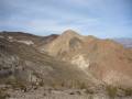
5.0 Canyon Split (1,580ft.). Stay right. The canyon narrows with interesting rock formations. You may run across several small dryfalls as you continue upcanyon. (35.837598°, -116.699213°)
6.0 20ft. Dryfall (2,210ft.). Retrace your steps to your vehicle. You might be able to find a way around the dryfall and continue upcanyon, but you’re not very far from the end here, and you’ve seen the best that Owlshead Canyon has to offer. (35.835981°, -116.711383°)
History & More
With only Talc Canyon to the north, Owlshead Canyon is the second-to-northernmost canyon in this section of the Owlshead Mountains. The canyon received its name from the mountain range.
The Amargosa River is 185 miles long, flowing from the Amargosa Valley to Death Valley, where it vanishes into an underground aquifer. It rarely flows above ground in this section except after rain or snowmelt – when it can turn into a dangerous waterway. Chances are you’ll only see water from December-April, though it can flow at any time of year. The word “Amargosa” comes from a Spanish word meaning “bitter.”
The canyons of the Owlshead Mountains are dry, extremely remote, and unmarked. Be prepared for self-rescue and to explore rather than follow a defined route.
Download Route Map
Driving Directions
The unmarked beginning of the route is 0.9 miles south of the northern end of the Harry Wade Road. If coming from the south, the “trailhead” is 18.3 miles beyond the Owl Hole Spring Road.
Camping in a canyon is discouraged due to the danger of flash floods.
Remember, it may be easier to climb up dryfalls than down them (or vice versa). Be sure you can climb in the other direction before climbing up or down a dryfall.
Camping is not allowed within one mile of a paved road, developed area, or dirt road that is closed to camping.
Camping is not permitted within 100 feet of a flowing stream, spring, or other natural body of open water.
No camping is permitted on the floor of Death Valley, within one mile of Darwin Falls and Greenwater Canyon, on the active/shifting sand dunes, and certain other canyons and backcountry areas.
Camping is also prohibited within one mile of the Ubehebe Lead Mine, Leadfield Mines, Keane Wonder Mill, and Skidoo Mill.
Camping is limited to 30 days per calendar year within the park.
Fires are permitted in NPS-provided fire grates or grills ONLY.
Leave No Trace Principles are enforced
Drones and model aircrafts are prohibited
Camping is permitted only in designated sites or in areas open to dispersed backcountry camping
All park rules and regulations
12 Month Pass: $55/Death Valley Annual Pass (valid at Death Valley National Park). $80/America the Beautiful Annual Pass (valid at all national park and federal fee areas). $20/Annual Senior Pass (62 years or older US citizens; valid at all national park and federal fee areas). Free/4th Grade Pass (Valid Sept. 1-August 31 of the child’s 4th Grade school year). Free/Military Pass (valid for all active military personel and their dependents with a CAC Card or DD Form 1173).
Lifetime Pass: $80/Lifetime Senior Pass (62 years or older US citizens; valid at all national park and federal fee areas). Free/Access Pass (available to all US citizens with perminent disabilities). Free/Access for Veterans and Gold Star Families Pass (valid for all military and veterans with a CAC card, Veteran HJealth Identification Card, Veteran ID Card, or veteran’s designation on state-issued drivers license or identification card.)