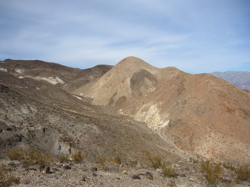
Smith Mountain – Death Valley National Park

Scramble up an unassuming but very pretty peak to fantastic views of the surrounding area. Total Distance: 5.6 miles out & back Elevation Gain: 2,314ft. (3,806ft. to 5,923ft.) Difficulty: Strenuous 5-10 Mile Difficulty: Strenuous View Rating: Author’s Rating: Visitor Rating: Visitor Difficulty Rating: Pets: No Horses: Yes Best Seasons: November-April Special Permits: None Water Availability: […]

Gold Valley Road – Death Valley National Park

Follow a 4×4 track off of the Greenwater Valley Road through the Black Mountains to Willow Spring and Gold Valley. Total Distance: 13.0 miles point-to-point (dead end) Elevation Gain: 1,432ft. up, 1,877ft. down (4,479ft. to 2,637ft.) Road Difficulty: 2.0 (4×4 required) Bicycle Difficulty: More Difficult View Rating: Author’s Rating: Visitor Rating: Visitor Difficulty Rating: Pets: […]

Greenwater Townsite Road (South) – Death Valley National Park

This is the southerly of the two roads leaving the Greenwater Valley Road to approach Greenwater Townsite. From Greenwater, it continues northwest to meet the Furnace Townsite Road. Total Distance: 5.6 miles point-to-point Elevation Gain: 1,077ft. up, 192ft. down (3,880ft. to 4,765ft.) Road Difficulty: 1.8 (high clearance required) Bicycle Difficulty: More Difficult View Rating: Author’s […]

Furnace Townsite Road – Death Valley National Park

Take a high clearance dirt road off of the Greenwater Valley Road to the quiet site of a tent city. Total Distance: 4.0 miles point-to-point (dead end) Elevation Gain: 1,582ft. up, 4ft. down (3,480ft. to 5,057ft.) Road Difficulty: 1.8 (high clearance required) Bicycle Difficulty: Very Difficult View Rating: Author’s Rating: Visitor Rating: Visitor Difficulty Rating: […]

Greenwater Valley Road – Death Valley National Park

Follow a high-clearance-required dirt road between the Greenwater Range and the Black Mountains to access historic and beautiful sites. Total Distance: 28.3 miles point-to-point Elevation Gain: 897ft. up, 2,026ft. down (2,101ft. to 4,060ft.) Road Difficulty: 1.5 (high clearance recommended due to washboard) Bicycle Difficulty: More Difficult View Rating: Author’s Rating: Visitor Rating: Visitor Difficulty Rating: […]

Brown Peak (East Approach) – Death Valley National Park

Scramble up an unassuming but very pretty peak to fantastic views of the surrounding area. Total Distance: 10.4 miles out & back Elevation Gain: 3,139ft. (1,833ft. to 4,949ft.) Difficulty: Extremely Strenuous 10+ Mile Difficulty: Very Strenuous View Rating: Author’s Rating: Visitor Rating: Visitor Difficulty Rating: Pets: No Horses: Yes Best Seasons: November-April Special Permits: None […]

Undertaker Canyon – Death Valley National Park

Scramble up a remote slot canyon in the Funeral Mountains off of Hole in the Wall Road to Widowmaker Dryfall. Serious scrambling is required – you may want ropes for this one. Total Distance: 5.0 miles out & back Elevation Gain: 1,917ft. (1,891ft. to 3,597ft.) Difficulty: Strenuous 0-5 Mile Difficulty: Very Strenuous View Rating: Author’s […]

Slit Canyon – Death Valley National Park

Hike to and up a remote slot canyon in the Funeral Mountains off of Hole in the Wall Road. Some scrambling is required. Total Distance: 9.4 miles out & back Elevation Gain: 3,029ft. (1,891ft. to 4,187ft.) Difficulty: Very Strenuous 5-10 Mile Difficulty: Extremely Strenuous View Rating: Author’s Rating: Visitor Rating: Visitor Difficulty Rating: Pets: No […]

Hole in the Wall Road – Death Valley National Park

Gravel/dirt road that gives access to Hole in the Wall and an old (mostly undeveloped) mining area. Total Distance: 6.0 miles point-to-point (dead end) Elevation Gain: 1,573ft. up, 5ft. down (992ft. to 2,562ft.) Road Difficulty: 1.2 for the first 3 miles; 2.0 beyond Bicycle Difficulty: More Difficult View Rating: Author’s Rating: Visitor Rating: Visitor Difficulty […]