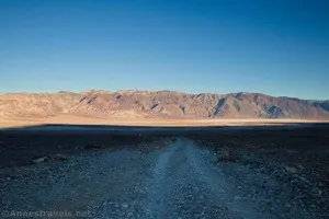
Furnace Townsite Road – Death Valley National Park

Take a high clearance dirt road off of the Greenwater Valley Road to the quiet site of a tent city. Total Distance: 4.0 miles point-to-point (dead end) Elevation Gain: 1,582ft. up, 4ft. down (3,480ft. to 5,057ft.) Road Difficulty: 1.8 (high clearance required) Bicycle Difficulty: Very Difficult View Rating: Author’s Rating: Visitor Rating: Visitor Difficulty Rating: […]

Greenwater Valley Road – Death Valley National Park

Follow a high-clearance-required dirt road between the Greenwater Range and the Black Mountains to access historic and beautiful sites. Total Distance: 28.3 miles point-to-point Elevation Gain: 897ft. up, 2,026ft. down (2,101ft. to 4,060ft.) Road Difficulty: 1.5 (high clearance recommended due to washboard) Bicycle Difficulty: More Difficult View Rating: Author’s Rating: Visitor Rating: Visitor Difficulty Rating: […]

CA-127 & NV-373 – Death Valley National Park

The state highway along the east side of Death Valley National Park, from Baker, CA (I-15) to US-95 north of Amargosa Valley, NV. Total Distance: 107.0 miles point to point Elevation Gain: 3,668ft. up, 1,939ft. down (406ft. to 2,663ft.) Road Difficulty: 0.6 Bicycle Difficulty: Easiest View Rating: Rating: Visitor Rating: Visitor Difficulty Rating: Pets: Leashed […]

Hole in the Wall Road – Death Valley National Park

Gravel/dirt road that gives access to Hole in the Wall and an old (mostly undeveloped) mining area. Total Distance: 6.0 miles point-to-point (dead end) Elevation Gain: 1,573ft. up, 5ft. down (992ft. to 2,562ft.) Road Difficulty: 1.2 for the first 3 miles; 2.0 beyond Bicycle Difficulty: More Difficult View Rating: Author’s Rating: Visitor Rating: Visitor Difficulty […]

Lee’s Camp Road – Death Valley National Park

Rough gravel/dirt road through mining country in the Funeral Mountains and past Lee’s Camp to a point near the “town” of Amargosa Valley. Total Distance: 18.2 miles point-to-point Elevation Gain: 1,658ft. up, 2,849ft. down (2,381ft. to 4,857ft.) Road Difficulty: 2.5+; 2.0 for southern 3 miles; 1.6 for northern 7.6 miles Bicycle Difficulty: Very Difficult View […]

CA-190: Furnace Creek to Stovepipe Wells

The main road through Death Valley between Furnace Creek and Stovepipe Wells. This guide begins where CA-190: Eastern border to Furnace Creek leaves off at Stovepipe Wells and connects to CA-190: Stovepipe Wells to Western Border. Total Distance: 24.2 miles point to point Elevation Gain: 1,049ft. up, 886ft. down (-249ft. to 150ft.) Road Difficulty: 0.6 […]

Echo Canyon Road – Death Valley National Park

Gravel/dirt road that gives access to Eye of the Needle Arch and the Inyo Mine. Total Distance: 10.9 miles point to point Elevation Gain: 3,729ft. up, 27.5ft. down (410ft. to 4,120ft.) Road Difficulty: 1.4 for the first 3 miles; 2.0 beyond Bicycle Difficulty: Very Difficult View Rating: Author’s Rating: Visitor Rating: Visitor Difficulty Rating: Pets: […]

Beatty Cutoff Road – Death Valley National Park

Cutoff road between CA-190 and the Daylight Pass Road. The southern end is at Beatty Junction and the northern end is at Hell’s Gate. Total Distance: 10.0 miles point to point Elevation Gain: 2,502ft. gain, 32ft. loss (-201ft. to 2,269ft.) Road Difficulty: 0.6 Bicycle Difficulty: Easy View Rating: Rating: Visitor Rating: Visitor Difficulty Rating: Pets: […]

Keane Wonder Access Road – Death Valley National Park

The gravel road used to access the Keane Wonder Trailhead. Total Distance: 2.8 miles point to point (dead end) Elevation Gain: 665ft. up, 230ft. down (676ft. to 1,325ft.) Road Difficulty: 1.2 Bicycle Difficulty: More Difficult View Rating: Rating: Visitor Rating: Visitor Difficulty Rating: Pets: Yes Horses: No Best Seasons: October-May Special Permits: None. Gate closes […]