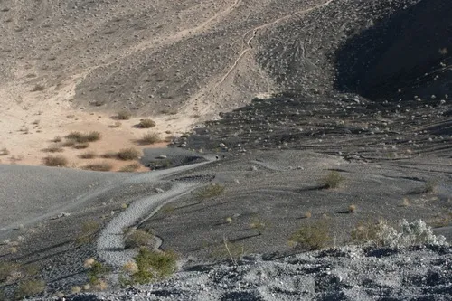
Ubehebe Crater Floor Trail – Death Valley National Park
Hike to the bottom of the Ubehebe Crater. The trail is very difficult due to the loose cinders.
| Total Distance: 0.8 miles out & back | Elevation Gain: 480ft. (2,590ft. to 2,123ft.) |
| Difficulty: Easy | 0-5 Mile Difficulty: Moderate |
| View Rating: 4.0 out of 5.0 stars | Author’s Rating: 4.0 out of 5.0 stars |
| Visitor Rating: (Click to rate) [Total: 0 Average: 0] | Visitor Difficulty Rating: (Click to rate) [Total: 0 Average: 0] |
| Pets: No | Horses: No |
| Best Seasons: October-May | Special Permits: None |
| Water Availability: None | Overnight Options: None |
| Trailhead Amenities: None | Crowd Factor: Moderate |
| Trailhead Access: 0.8 | |
| Uses: | Trail Surface: |
| Features: | Hazards: |
Mile-by-Mile: Ubehebe Crater Floor Trail
0.0 Ubehebe Crater Northern Trailhead (2,590ft.). Take the Rim Trail clockwise north (left while looking at the crater). (37.011234°, -117.454762°)
0.1 Ubehebe Crater Floor Trail Junction (2,531ft.). Turn right down the trail toward the bottom of the crater. (37.012673°, -117.454298°)
0.4 Bottom of the crater (2,123ft.). Enjoy views up at the cindery sides before beginning the arduous climb back to the rim. (37.009905°, -117.450990°)
History & More
While the trail is technically “easy” or “moderate,” the route is very steep with loose cinders, making hiking extremely difficult. Do not attempt on a hot day (the black cinders absorb and radiate heat) or unless you are in good condition. Remember, hiking down is much easier than hiking back up!
Ubehebe is pronounced “YOO-bee-HEE-bee.”
The crater is approximately half a mile wide and 777ft. deep.
No one knows exactly when the crater was formed. Scenarists estimate that it’s between 800 and 7,000 years old.
The name “Ubehebe” was first used to describe Ubehebe Peak, 24 miles to the southwest. No one knows how the name became associated with the crater.
Download Trail Map
Coming soon!
Driving Directions
Take the Scotty’s Castle Road to the Ubehebe Crater Road (3 miles south of Scotty’s Castle and 0.2 miles north of the Grapevine Ranger Station). Drive the Ubehebe Crater Road 6 miles to the end of the paved road and the Ubehebe Crater Trailhead.
Leave No Trace Principles are enforced
Drones and model aircrafts are prohibited
Camping is permitted only in designated sites or in areas open to dispersed backcountry camping
Click here for all park rules and regulations
12 Month Pass: $55/Death Valley Annual Pass (valid at Death Valley National Park). $80/America the Beautiful Annual Pass (valid at all national park and federal fee areas). $20/Annual Senior Pass (62 years or older US citizens; valid at all national park and federal fee areas). Free/4th Grade Pass (Valid Sept. 1-August 31 of the child’s 4th Grade school year). Free/Military Pass (valid for all active military personel and their dependents with a CAC Card or DD Form 1173).
Lifetime Pass: $80/Lifetime Senior Pass (62 years or older US citizens; valid at all national park and federal fee areas). Free/Access Pass (available to all US citizens with perminent disabilities). Free/Access for Veterans and Gold Star Families Pass (valid for all military and veterans with a CAC card, Veteran HJealth Identification Card, Veteran ID Card, or veteran’s designation on state-issued drivers license or identification card.)


1 thought on “Ubehebe Crater Floor Trail – Death Valley National Park”